The Queen Maeve Trail is a strenuous uphill walk on Knocknarea Mountain near Strandhill, County Sligo, leading to Queen Maeve’s Cairn and wide views across Sligo Bay.
The main Strandhill ascent is about 2.3km one way and climbs roughly 300 metres, so it is short on paper but not a casual stroll. Expect forest paths, steps, a raised bog bridge and more than 500 wooden steps before the open summit.
For walkers who want a compact Wild Atlantic Way hike with real archaeological weight behind it, this is one of Sligo’s most memorable climbs. Bring water, wear decent footwear and save some energy for the descent.
What Is the Queen Maeve Trail?
The Queen Maeve Trail climbs the northern side of Knocknarea Mountain, the distinctive limestone hill west of Sligo town on the Cúil Irra peninsula. The summit stands 327 metres above sea level and is crowned by Miosgan Meadhbha, commonly known as Queen Maeve’s Cairn.
The cairn is a protected National Monument, about 55 metres across and 10 metres high. It is generally dated to around 3400 BC, making it substantially older than the medieval legends attached to it. Local tradition identifies it as the burial place of the warrior queen Maeve of Connacht, said to be buried upright with a spear.
That legend is part of the appeal, but the site is also a sacred burial landscape. Do not climb the cairn or disturb stones around it. The path brings you to the summit without needing to step onto the monument.
Queen Maeve Trail Route at a Glance
| Detail | What to Expect |
|---|---|
| Location | Knocknarea Mountain, near Strandhill, County Sligo |
| Summit height | 327m |
| Strandhill ascent | About 2.3km one way |
| Elevation gain | About 300m on the Strandhill route |
| Terrain | Gravel paths, timber and gravel steps, forest track and raised bog bridge |
| Waymarking | Red arrows on the upland trail network |
| Time needed | Allow about 2 to 3 hours for a return walk with summit time |
Published route distances can look confusing because Knocknarea has more than one approach and a longer marked trail network. The Strandhill route is commonly described as a 2.3km linear climb to the summit, while Sligo Walks lists an 8km strenuous upland walk with 327 metres of ascent. Choose the route description that matches your starting point and planned return.
Starting From Strandhill
The Strandhill entrance is the most convenient choice for people based in the village. The trailhead sits opposite Sligo Rugby Club, a short drive from Strandhill Beach and about 500 metres along the R292 from the village approach.
On non-match days, parking may be available at Sligo Rugby Club, opposite the entrance. There is also limited roadside parking nearby. Do not block access or assume club parking is available during fixtures, and arrive early on busy weekends if you want the simplest start.
The route begins gently enough through pine forest, then makes its intentions clear. The climb becomes sustained, with timber sections and a long run of wooden steps. The raised bog bridge is useful underfoot, but exposed sections can feel slippery in rain and wind.
What the Walk Is Actually Like
The Queen Maeve Trail has a satisfying rhythm: trees first, then steps, then a sudden release onto the broad summit plateau. The forest takes some of the sting out of the early ascent, while the open upper slopes make the weather impossible to ignore.
The 500-plus wooden steps are the section most people remember. They are not technical, but they demand steady pacing, especially when wet. Take breaks where the path widens, keep moving predictably on narrow sections and let faster walkers pass without turning it into a mountain race.
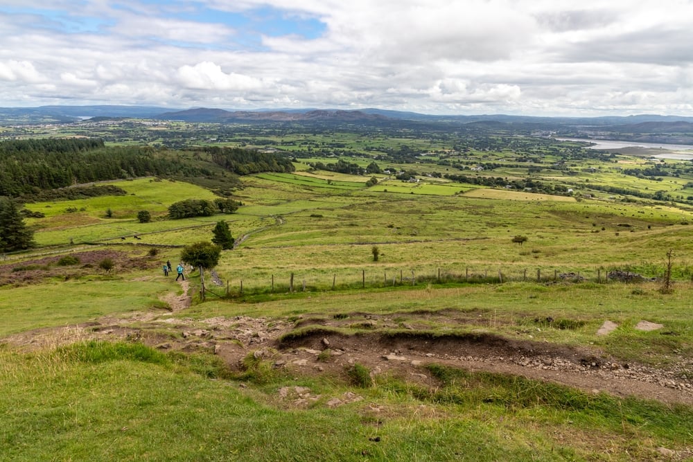
At the top, the payoff is an extensive view over Sligo, Ballisodare Bay and the Atlantic coast. Clear conditions can also reveal Coney Island, Rosses Point, County Leitrim, Donegal’s Sliabh Liag cliffs and, farther south-west, Nephin in County Mayo.
Which Queen Maeve Trail Route Should You Choose?
For a direct out-and-back hike, start in Strandhill. It is the practical option for anyone staying in the village, using the R292 from Sligo town or planning to combine the walk with time at Strandhill Beach.
A second approach begins at Primrose Grange on the other side of Knocknarea. This side has parking and a steeper initial push, with views back toward Lough Gill when you stop to catch your breath. It suits drivers who prefer the eastern approach and do not mind a sharper opening climb.
The main car park reached via the L3503 and Glen Road is another useful access point for the wider Knocknarea walking network. Sligo Walks advises continuing beyond the smaller Rathcarrick car park to the larger main car park where possible.
What to Wear and Bring
This is an upland walk, even though the trail begins close to the coast. Sturdy hiking boots are the sensible choice for wet steps, gravel and uneven ground around the summit. Trainers can be uncomfortable and slippery after rain.

NORTIV 8 Men's Ankle High Waterproof Hiking Boots,Brown/Black/Tan,10.5W | Outdoor Lightweight Hiking Boots for Camping, Trekking and Mountaineering Armadillo
Pack water and a snack, then add a waterproof layer even if Strandhill looks bright when you set off. Knocknarea is exposed at the top, and cloud or wind can arrive faster than the route length suggests. A charged mobile phone is also recommended, but it is not a substitute for checking conditions and using common sense.
- Wear boots with grip for timber steps and wet gravel.
- Carry water, especially on warm days, because the climb is continuous.
- Bring a light waterproof and an extra warm layer for the summit.
- Keep dogs on a lead and avoid bringing them during the February to April lambing season.
- Stay on the marked route and keep off Queen Maeve’s Cairn.
Best Time to Walk the Queen Maeve Trail
A dry, clear morning gives you the best chance of long coastal views and a quieter trail. Weekends can be busy, particularly at the Strandhill entrance, so an earlier start usually makes parking and passing on the steps easier.
Do not judge the summit by conditions at sea level. Low cloud can remove the view entirely, while strong wind can make the exposed plateau unpleasant. If visibility is poor, the trail is still a worthwhile workout, but the summit panorama is a major part of the experience.
The route is closed for one day each December for essential maintenance work. Check local trail notices before setting off, especially after severe weather, because the Queen Maeve Trail has previously required closure and restoration following storm damage.
Pair the Hike With Carrowmore and Strandhill
The nearby Carrowmore Megalithic Cemetery is the best place to add context to Knocknarea’s prehistoric landscape. Its passage tombs, stone circles and interpretive centre help explain why this corner of County Sligo has long been an important ritual landscape.
Back in Strandhill, the beach and seafront are an easy place to decompress after the descent. The village also has cafés, pubs and restaurants, making it a practical base for a half-day hike instead of a rushed there-and-back from Sligo town.
If you are making a weekend of the walk, stay in or near Strandhill, County Sligo so the trailhead is close and you can choose a clear weather window without a long morning drive. For another full-day Irish walk with woodland, shorelines and archaeological sites, see Ards Forest Park’s trails, beaches and ring forts.
Is the Queen Maeve Trail Worth It?
Yes. The Queen Maeve Trail is worth doing if you are comfortable with a sustained climb and want a hike that combines coastal views, well-made trail infrastructure and one of Ireland’s most striking Neolithic monuments.
It is less suitable for anyone seeking a flat promenade or a quick viewpoint with almost no effort. The route is steep enough to earn the views, and the wooden stairs have no interest in negotiating. Go at a steady pace and the walk is manageable for many reasonably fit people.
Queen Maeve Trail FAQ
How long does the Queen Maeve Trail take?
Allow around 2 to 3 hours for a return hike, including breaks and time at the summit. The Strandhill route is about 2.3km one way, but the steep ascent and steps slow the pace.
How difficult is the Queen Maeve Trail?
The Queen Maeve Trail is considered strenuous because it climbs about 300 metres over a relatively short distance. It is a maintained trail, but steep steps, loose gravel and exposed summit conditions require sound footwear and reasonable fitness.
Can you climb Queen Maeve’s Cairn?
No. Queen Maeve’s Cairn is a protected National Monument and a sacred burial place. Stay on the surrounding paths and do not climb or remove stones from the cairn.
Where do you park for the Queen Maeve Trail?
For the Strandhill entrance, parking may be available at Sligo Rugby Club on non-match days, with limited roadside parking nearby. The wider Knocknarea network also has access via Rathcarrick and the larger main car park reached from the Glen Road.
Can dogs go on the Queen Maeve Trail?
Dogs are allowed on a lead, but should not be brought during the February to April lambing season. Keep them controlled around livestock, other walkers and the archaeological sites.