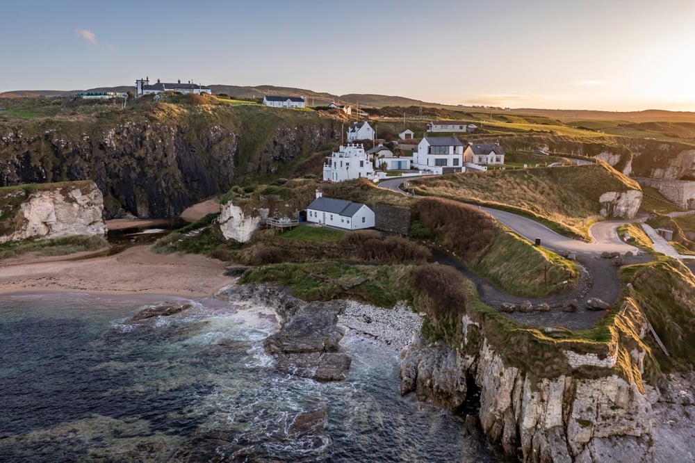
If Ballintoy Harbour is on your Causeway Coast list, the short version is this: it’s a small, free-to-visit fishing harbour at the bottom of a steep, narrow road, with sea stacks, rock pools and a tea room on the quay. It sits on Harbour Road, Ballintoy, BT54 6NA, about five miles west of Ballycastle and 17 miles north-east of Coleraine in County Antrim, Northern Ireland.
It’s also busy. The harbour car park is small, the road down is no place for a big vehicle, and Game of Thrones fans have been coming since the show used it for the Iron Islands.
Ballintoy Harbour at a Glance
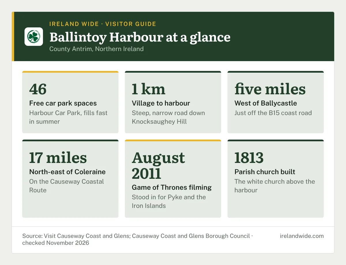
- Where: Harbour Road, Ballintoy, County Antrim, BT54 6NA, about 1 km below Ballintoy village.
- Cost: free to visit; the council lists the harbour car park as free.
- Parking: 46 spaces in the Harbour Car Park, which fill fast on summer days.
- Facilities: toilets, a picnic area and a tea room on the quay.
- Game of Thrones: used for exterior Pyke shots and the Iron Islands in seasons 2 and 6.
- Currency: it’s in Northern Ireland, so prices are in pounds sterling, not euro.
Where Is Ballintoy Harbour and How Do You Get There?
Ballintoy Harbour is on the north Antrim coast, just off the B15 coast road between Ballycastle and the Giant’s Causeway. The village of Ballintoy sits up on the main road; the harbour is roughly 1 km below it, down a single road that drops off Knocksaughey Hill. Coming from Ballycastle, you pass the entrance to Larrybane and the Carrick-a-Rede Rope Bridge on the way, so it slots neatly into a day on the Causeway Coastal Route.
Driving Down to the Harbour
The final approach is a small, narrow, steep road with tight bends. In a normal car it’s easy enough if you take it slowly and expect to meet someone coming up. There’s a catch for anyone in a campervan: a sign on the main road warns that the road isn’t suitable for motorhomes, and plenty of drivers in larger vans turn back at the top.
If you’re in something big, park up in the village and walk down. It’s about 1 km each way, and the walk back up is the bit you’ll feel.
Getting to Ballintoy Harbour by Bus
Ulsterbus route 402, the Causeway Rambler between Portrush and Ballycastle, stops in Ballintoy village at the school, the Gospel Hall and Main Street. The service links Coleraine, Portrush, Dunluce Castle, Bushmills, the Giant’s Causeway and Carrick-a-Rede, so you can see the coast without a car. In the November 2026 timetable it calls at Ballintoy roughly every 30 minutes through the day, with the last winter bus back towards Portrush leaving the Gospel Hall at 6.50pm.
The bus doesn’t go down to the harbour. From the Gospel Hall stop it’s a walk down Harbour Road, past the church, to the quay. Give yourself time for the climb back up before the last bus, and check the Translink timetable on the day, because the 402 runs a seasonal schedule and stops can be suspended during events such as the Lammas Fair in Ballycastle.
Parking at Ballintoy Harbour
The council’s Harbour Car Park has 46 spaces and is listed as free. It sits right beside the harbour café, so you’re parked within a minute of the water. A second free council car park, Portaneevy, has 49 spaces up on the main road towards Carrick-a-Rede and doubles as a clifftop viewpoint, though it’s 1.76 miles from the harbour.
The harbour car park is a bit of a pain in peak season. Cars tend to stay all day, so spaces turn over slowly, and when it’s full you’re doing a slightly awkward turn at the bottom of a narrow hill. A few things help:
- Arrive early in July and August, or come in the late afternoon once day-trippers leave.
- Outside summer, parking is usually easy enough, especially on weekdays.
- If the harbour is full, park in the village and walk down, or drive on to Portaneevy.
- Don’t park on the verges of Harbour Road; it’s a working road for residents and the harbour.
What to See and Do at Ballintoy Harbour
The harbour itself is small: a stone quay, a slipway, a handful of boats and a car park. What brings people down is the setting. The harbour sits on a raised beach, with limestone and basalt cliffs behind it and a scatter of sea stacks, rocky islands and pools in front. On a clear day you can see Sheep Island just offshore and Rathlin Island further east.
Sea Stacks and Rock Pools
Walk west from the car park along the shore and the rocks open up into a series of stacks and shallow pools. It’s good ground for poking around with kids at low tide, and it’s the stretch that features in the filming. The rock is uneven and slippery when wet, so wear proper shoes and keep an eye on the tide if you head out onto the outer rocks.
Swimming and Water Sports
Swimmers do use the sheltered water by the harbour, and paddleboarders and kayakers launch from the slipway in summer. This is open North Atlantic coast, though. Only swim if you’re experienced in cold sea water, go with someone, check the tide and the forecast first, and stay out when there’s a swell running. If you’d like to try the water with a guide, kayak and coasteering operators work along this stretch of coast in the warmer months.
Roark’s Kitchen Tea Room
Roark’s Kitchen, at 58 Harbour Road on the quayside, is the tea room you’ll see from the car park. It serves teas, coffees, ice cream and lunch dishes, and it has a reputation for being cash only, so bring some sterling. Hours vary through the year, so check before you count on lunch there, especially in winter. The Fullerton Arms pub up in the village is the other option nearby.
Toilets and Picnic Area
There are public toilets and a picnic area by the harbour car park, which is handy since there isn’t much else at the bottom of the hill. The nearest shops are up in the village.
Ballintoy Harbour Game of Thrones Scenes
Ballintoy Harbour was used for exterior Pyke shots and as the Iron Islands in HBO’s Game of Thrones. Filming took place in August 2011, and the village stood in for Lordsport, the harbour town on the Isle of Pyke.
The scenes filmed here include:
- Season 2, Episode 2: Theon Greyjoy lands back on Pyke and first meets his sister Yara.
- Season 2, Episode 3: Theon is baptised in the sea.
- Season 6, Episode 5: Euron Greyjoy’s drowning and rebirth.
You’ll recognise the harbour wall and the rocks to the west straight away.
Ballintoy Parish Church on the Way Down
The white church you pass on Harbour Road is Ballintoy Parish Church, a Church of Ireland building on the hill above the harbour. The present church was built in 1813 and keeps the tower of an older church on the site. Its steeple was taken down after a hurricane hit the north coast in December 1894, which explains its low, squared-off look today.
It’s worth a short stop. The sundial on the side of the church dates from 1817 and was used to record the tides, and the graveyard holds the war graves of sailors from HMS Racoon and HMS Viknor, both lost in the First World War. Rev. Robert Trail served as minister here for 66 years. The church is usually open during daylight hours, with level access to the main areas and parking nearby. Each Easter Sunday a dawn service is held down at the harbour itself.
Walks From Ballintoy Harbour
The harbour car park is a start point on the Causeway Coast Way, and the walk west along the shore is the best way to see why the area gets so much attention. You don’t need to do the full route to get a lot out of it.
Ballintoy Harbour to Whitepark Bay
Head west from the car park past low dunes and pasture, cross a stile, and follow the path past the rock stacks to the eastern end of Whitepark Bay. Whitepark Bay is about 1.64 miles from the harbour, a long sandy beach that’s easy to walk along. Turn round at the beach for a relaxed out-and-back, allowing a couple of hours, or carry on if you’ve arranged a lift or a bus at the far end.
Ballintoy to Bushmills on the Causeway Coast Way
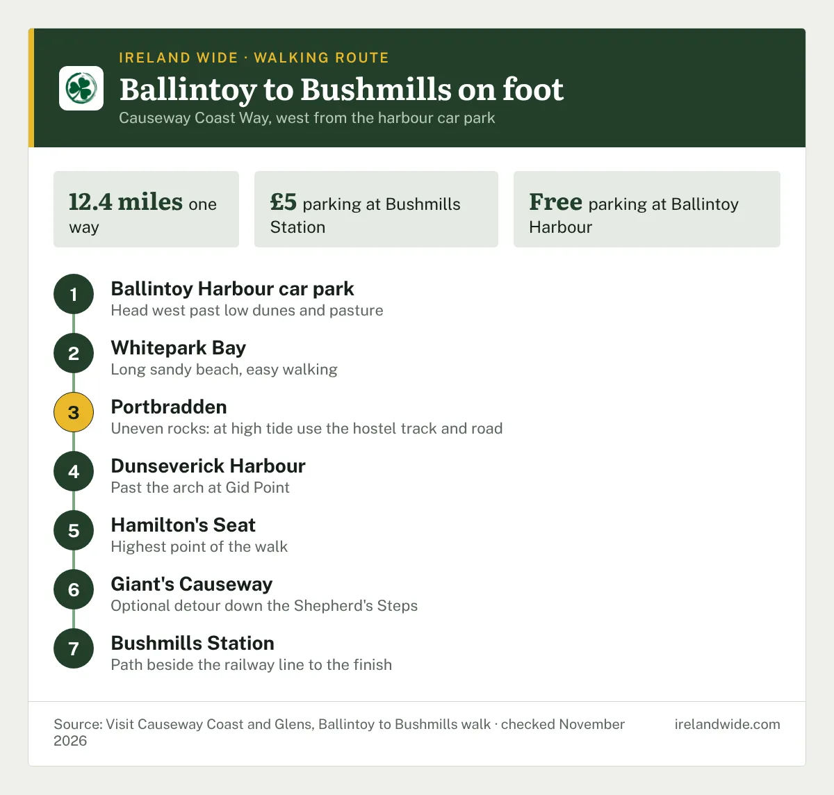
The full Ballintoy to Bushmills walk is 12.4 miles, starting at the Ballintoy Harbour car park and finishing at Bushmills Station on Ballaghmore Road. The route goes:
- West along the shore to Whitepark Bay and along the beach.
- Over uneven rocks and chalk boulders to Portbradden. At high tide, use the track at the youth hostel and the road down to Portbradden.
- Past the arch at Gid Point and a series of rocky bays to Dunseverick Harbour.
- Along the clifftops past Portmoon, Contham Head and Benbane Head to Hamilton’s Seat, the highest point on the walk.
- Past Port na Spaniagh and the Amphitheatre to the Giant’s Causeway, with an optional detour down the Shepherd’s Steps.
- Along the path beside the railway line to Bushmills Station.
Check the tide times before you set out, since the Portbradden rocks are the awkward part. Parking is free at Ballintoy Harbour and in Bushmills town centre, while Bushmills Station charges £5. The 402 bus is the easy way back to your car.
How Far Is Ballintoy Harbour From Nearby Sights?
Ballintoy is a handy base for the eastern half of the Causeway Coast. These are the distances from the harbour to the main stops nearby:
Filter the stops by type to see which are closest to the harbour.
| Place | Distance from the harbour | What it is |
|---|---|---|
| Carrick-a-Rede Rope Bridge | 1.48 miles | National Trust rope bridge to a small island |
| Whitepark Bay | 1.64 miles | Sandy beach on the Causeway Coast Way |
| Portaneevy Viewing Point | 1.76 miles | Clifftop viewpoint and free car park |
| Dunseverick Castle | 3.15 miles | Ruined castle on a headland |
| Kinbane Castle | 3.23 miles | Castle ruin on a narrow headland |
| Giant’s Causeway | 5.87 miles | Basalt columns and visitor centre |
| Ballycastle Beach | 6.41 miles | Town beach in Ballycastle |
| Old Bushmills Distillery | 6.58 miles | Whiskey distillery in Bushmills |
Carrick-a-Rede is the one most people pair with the harbour. Pre-booking is essential to cross the rope bridge, tickets start from £15.00 for an adult at off-peak times and include parking, and the bridge is a 1 km walk from the car park with steps and uneven ground. It closes in high winds, so check on the morning you go.
If you’re fitting the Causeway Coast into a longer trip, our 10-day Ireland itinerary for American travellers shows how the north can link up with the rest of the island.
When to Visit Ballintoy Harbour and How Long to Spend
An hour is enough to walk the shore, look at the stacks and have a cup of tea. Add a couple of hours if you’re walking to Whitepark Bay and back, or make a full day of it with the Ballintoy to Bushmills route.
Summer gives you the longest days and the tea room at its most reliable, but the car park is absolutely packed by late morning. Spring and autumn are quieter and still bright enough for the walk. Winter visits are fine for a short stop; just expect wind, early dark and fewer services. Low tide is the best time for the rock pools and for the Portbradden section of the walk.
Ballintoy Harbour FAQ
Is Ballintoy Harbour free to visit?
Yes. Ballintoy Harbour is an open public harbour with no entry charge, and the 46-space Harbour Car Park beside it is listed by Causeway Coast and Glens Borough Council as free.
Can you take a motorhome down to Ballintoy Harbour?
It isn’t recommended. The road down to Ballintoy Harbour is narrow, steep and twisting, and a sign on the main road warns it is unsuitable for motorhomes, so larger vehicles are better parked in the village or at Portaneevy.
Is Ballintoy Harbour in Northern Ireland or the Republic?
Ballintoy Harbour is in County Antrim, Northern Ireland, which is part of the UK. Prices are in pounds sterling, and visitors driving up from the Republic of Ireland will find speed limits shown in miles per hour.